


Cartography
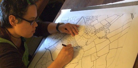
Cartography is the science and art of creating maps, which are visual representations of the Earth's surface or other geographic information. Cartographers, or mapmakers, use a combination of science, technology, and design principles to create maps that convey information about the physical, cultural, and spatial aspects of the world. It is a fascinating career that involves the study of geographic information and the skill of visual representation.
Cartographers play a crucial role in the creation of accurate and detailed maps, which are essential for various purposes such as navigation, urban planning, natural resource management, and research. Cartographers follow various principles, including accuracy, readability, generalization (simplification of complex features), and aesthetic considerations to create effective and informative maps. It helps people understand and navigate the world around them, make informed decisions, and communicate geographic information effectively.
Role Desciption
The primary responsibility of cartographers is to collect, analyze, interpret, and present geographic data on maps. They work with advanced technology and software to create detailed and accurate maps. Some of the common tasks performed by cartographers include:
- Data Collection: Cartographers gather geographic data from various sources, including satellite images, aerial photographs, survey data, and field observations.
- Data Analysis: They analyze the collected data to identify patterns, trends, and relationships that can be represented on maps.
- Map Creation: Cartographers use specialized software to convert data into visually appealing and informative maps. This involves creating map layouts, selecting appropriate symbols and colors, and applying cartographic principles.
- Quality Assurance: Cartographers ensure the accuracy, completeness, and quality of maps by conducting thorough reviews and applying quality control techniques.
- Communication and Collaboration: Cartographers often collaborate with other professionals, such as geographers, urban planners, and environmental scientists, to integrate spatial information into their projects. They also communicate with clients to understand their requirements and effectively present the maps.
Eligibility
Educational Pathway
Route 1
- 10+2 in any stream with Mathematics
- Bachelor’s degree in geography/ geology/ environment science
- Master's degree in geospatial science
Route 2
- 10+2 in any stream with Mathematics
- Bachelor’s degree in geography/ geology/ environment science
- Postgraduate diploma in GIS/ Cartography
Pros/Cons
Pros:
- Dynamic field with continuous advancements in technology
- Opportunities to work on exciting projects related to urban planning, disaster management, and environmental conservation
- High demand for skilled cartographers in various industries
- Ability to make a significant impact by creating accurate and informative maps
Cons:
- Requires continuous learning to stay updated with evolving software and technologies
- Can involve long hours of work, especially during project deadlines
- Limited job opportunities in certain geographical areas, primarily in rural regions
- Potential challenges in accessing accurate and reliable data sources in some cases
Leading Professions
View All
GIS/Remote Sensing Specialist
Geographic Information S...
7.0LPA

Geographic Information Systems Analyst
GIS analysts use GIS sof...
6.0LPA
Cartographer
Cartographers are respon...
8.0LPA

Geospatial Intelligence Analyst
Geospatial intelligence ...
8.0LPA

Geographer
Geographers study spatia...
10.0LPA

Surveyor
Surveyors gather and mea...
6.0LPA

Geospatial Project Manager
Geospatial project manag...
18.0LPA

Web Mapping Specialist
As maps and spatial data...
5.0LPA

CAREER VIDEOS
Career Path
10+2 in any stream with Mathematics
1 Steps
Skills
Recruitment Area
Government Agencies ,
Private Mapping and GIS Companies ,
Research Institutions ,
Educational Institutions .
Recruiters
Geographical Survey of India ,
National Remote Sensing Centre ,
ESRI India ,
RMSI ,
Geospatial Media and Communications ,
MapmyIndia .
Explore Colleges
Exams & Tests
Interested? Take the next step for this career
10+2 in any stream with Mathematics
- 1 Steps
Skills Needed
Exams and Tests
Recruitment Area
Government Agencies ,
Private Mapping and GIS Companies ,
Research Institutions ,
Educational Institutions .
Recruiters
Geographical Survey of India ,
National Remote Sensing Centre ,
ESRI India ,
RMSI ,
Geospatial Media and Communications ,
MapmyIndia .